
Philip S. Prince, Project Geologist
Knowing where landslides have happened in the past is a key part of understanding where they may occur in the future. Finding old landslides in the rugged, thickly-forested mountains of western North Carolina can be quite a challenge to geologists limited to field reconnaissance and aerial photography. The landslide search in our region has been revolutionized in recent years by the availability of land surface imagery derived from Lidar, which allows geologists to see what the ground looks like without its covering of vegetation. The GIF below demonstrates this technology by draping a lidar-derived land surface image over Google Earth aerial photography. A significant landslide, which is entirely invisible in the aerial photography, is easy to see just above the center of the lidar image.

The landslide feature visible in the lidar imagery was previously undocumented despite its size (the scar area near the mountaintop is a bit over 130 feet wide) and its proximity to developed areas along US 64 in Transylvania County. The age of the slide is unknown, although we expect it may have occurred during rainfall events that caused the major flood of 1916. This landslide is particularly interesting because it progressed to a debris flow, a highly mobile and fluidized landslide that can travel significant distances. The debris flow scoured the channel leading down the slope from the prominent slide scar, widening and deepening it significantly. Compare the scoured channel below the slide to the ravine to its right, which has not been similarly shaped by a landslide or debris flow.
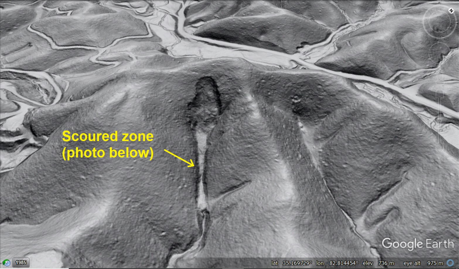
The scoured area is up to 40 feet wide and 15 feet deep in places. The following photo, captured by ALC geologist Aras Mann at the point indicated by the yellow arrow above, provides a nice perspective on the field appearance of the scoured zone. The photo also shows the thick covering of vegetation so common in rugged terrain in the region. This thick vegetation makes it impossible to stand anywhere and observe more than a very small portion of the slide at one time. Lidar imagery in conjunction with GPS position (on the computer on the shoulder strap) fixes this problem, allowing geologists to observe their position with respect to landscape features no matter how thick the laurels may be.

The next photo shows a small portion of the large scar where the landslide initially detached, which is equally vegetated. The steep walls, or scarps, between the slide area and intact slope are definitely noticeable from the ground, but the overall context of the landslide can really only be appreciated with lidar-derived imagery. The steep slope to my left in the photo below is the right edge of the large upper slide scar visible in the lidar image. Outcrops of weak, chippy phyllite bedrock in which the slide occurred are visible at the left of the photo.

Lidar-derived imagery is fundamental to the vast majority of ALC’s work, but the human element remains equally important. Lidar imagery must be evaluated by geologists who are familiar with both the field expression of a variety of landslide processes and what those landslides might look like in the lidar imagery. Much like the CAPTCHA photo arrays in which only humans can distinguish buses from trains, lidar-imaged landscapes cannot be analyzed for landslides by computer programs–only a skilled human can do it. The lidar image below provides an interesting example of very subtle but significant landslide features that require a trained eye for identification. The yellow arrows point out two debris flow features above Highway 178 in Transylvania County. Again, their age is unknown, but they occurred upslope of a currently inhabited area and are thus of interest from a public safety standpoint. Can you see them?
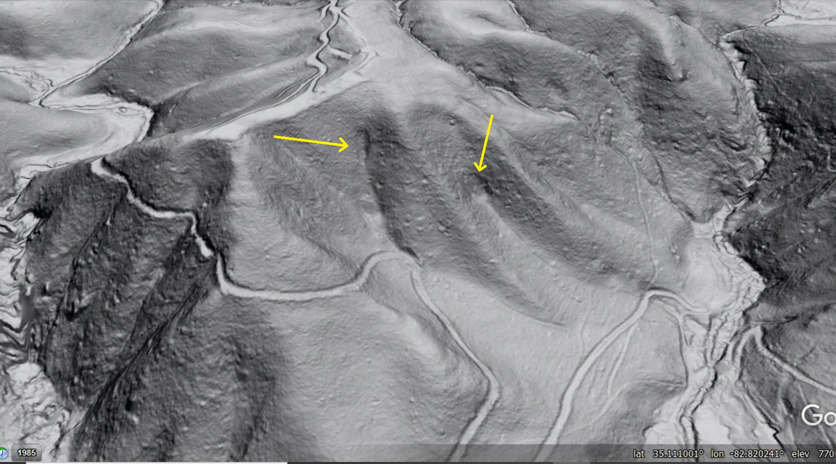
The debris flows are identifiable by the crisp edges on the “spoon bowl”-shaped scars they left on the hillside. An even closer look reveals lumps of debris (small boulders) deposited by the flows on the flatter ground below. Clicking on the image to open it in its own window should enlarge and make details easier to see. In the image below, I have outlined the general track of the debris flows as well as the area of obvious deposited material. The deposits are subtle, but they are definitely visible as small “crumbs” on the the land surface within the wider portions of the outlines. When the flows occurred, wood and saturated soil likely traveled even further, but signs of this material are now absent from the landscape. Again, clicking on this image to see it in its own window should make the details more apparent.

A glimpse at the landscape surrounding these features reveals all sorts of bumps and divots on the land surface which make it impossible for computer algorithms to single out landslide-related landforms. We have confirmed both of these features in the field (they are as vegetated as the US 64 slide), and, like all the features we visit, they have improved our pattern recognition skills and our understanding of slope failure events that can occur in the North Carolina mountains. ALC strives to apply this understanding to improving landslide awareness and public safety throughout western North Carolina and the southern Appalachians.
