
by Philip S. Prince
*Note: There is indeed a sand model in this post, but it’s near the end…
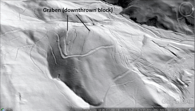
Well, it’s more of a hilltop, but it has dropped several feet since iron mining was active on its lower slopes in the early 20th century! The summit of this unnamed hill southwest of Low Moor, Virginia, hosts conspicuous scarps that define a graben, or downthrown block, that has sunk about 6 ft (just under 2 m) relative to the surrounding hilltop. The graben is a bit over 300 ft (100 m) wide. The scarps are subtle but very clearly visible in 1-meter resolution, lidar-derived hillshade imagery. Results of iron mining are visible at lower right in the upper image below (more on this later, for sure).


The scarps (which face outwards and downhill) and counter-scarps (which face inward, or towards the upslope direction) do not appear to cut road grades on the slope. They do, however, offset a prospect trench within the subsided graben. The slope movement thus post-dates the trench, but was likely gradual and episodic over the course of months or years. I don’t know if movement would have been discernible during the period that mining was active, or if it completely post-dates work at the site.

Disturbance of the prospect trench puts movement on the scarps within, or after, the iron mining period, which is consistent with other iron-mine related features in Alleghany and Botetourt Counties in Virginia. I have written about these other iron mine-related landslides before (click here), but the summit graben shown here is unique because of its position on the slope and its 300 ft / 100 m width relative to the overall scale of the affected hill. Because of the graben’s position on the hill and its width, deformation is likely seated very deep within the hill. The slow-moving GIF below shows an interpretive cutaway of the slope, with shear planes sketched in from the shape of the slope and reasonable angular relationships.
Interpretive is the key word here…I have not even been to this site in person, so I am just inferring a possible subsurface structure from surface deformation and the size and shape of the hill and graben. That said, the graben is quite large with respect to the size of the hill, and its position so far from the toe of the slope definitely implies very deep-seated movement. This is certainly not a thin, translational bedrock-involved slide of the type that is common within the Appalachian Valley and Ridge. The outwardly-moving hillslope is not a dip slope in the first place, and the scale and position of the graben make a shallow translational explanation impossible. A slightly zoomed version of the subsurface interpretation is shown below. Note that the cut of the diagram is a bit out of plane of the oblique image and slightly exaggerates relief and the thickness of the moving area.

Where does the iron mining factor into the story? Highwall surface mining for limonite ores occurred along the foot of the hill in the early 20th century. The workings were not exceptionally large, but they did tend to make contour-parallel cuts along the foot of the slope. The largest of these (the one visible at lower right in the post’s first image) appears to have experienced a major collapse. The other cuts also show indication of slope movement, though it is less pronounced. Mined areas and their location with respect to the graben are shown below.

Even though the mined areas aren’t exceptionally extensive, they obviously destabilized the slope in proximity to the cuts; small parallel scarps are visible upslope of the mined areas in the image above. Presumably, this destabilization and associated slope movement turned out to be very far-reaching, allowing the whole hill to expand a bit laterally and force graben subsidence. The following GIF offers a simplified, cartoon-style interpretation of the process.

This style of slope movement suggests that hillslopes in the area may be near a deep-seated stability threshold that makes them susceptible to modest but volumetrically significant movement in response to very minor surface modification. This susceptibility may be a reflection of bedrock geology and structure. This area is underlain by a complexly folded and faulted sandstone and limestone interval with thick shales above and below. The result is shale-cored mountain topography that is “propped up” by the strength of armoring sandstones. Additionally, the area has experienced considerable geologically-recent relief production due to its location in the James River basin, so slopes have grown taller and steeper as valleys have lowered. Given these background conditions, potential slope behavior under disturbance could be expected to be different from the behavior of a more geologically consistent, lower relief landscape.
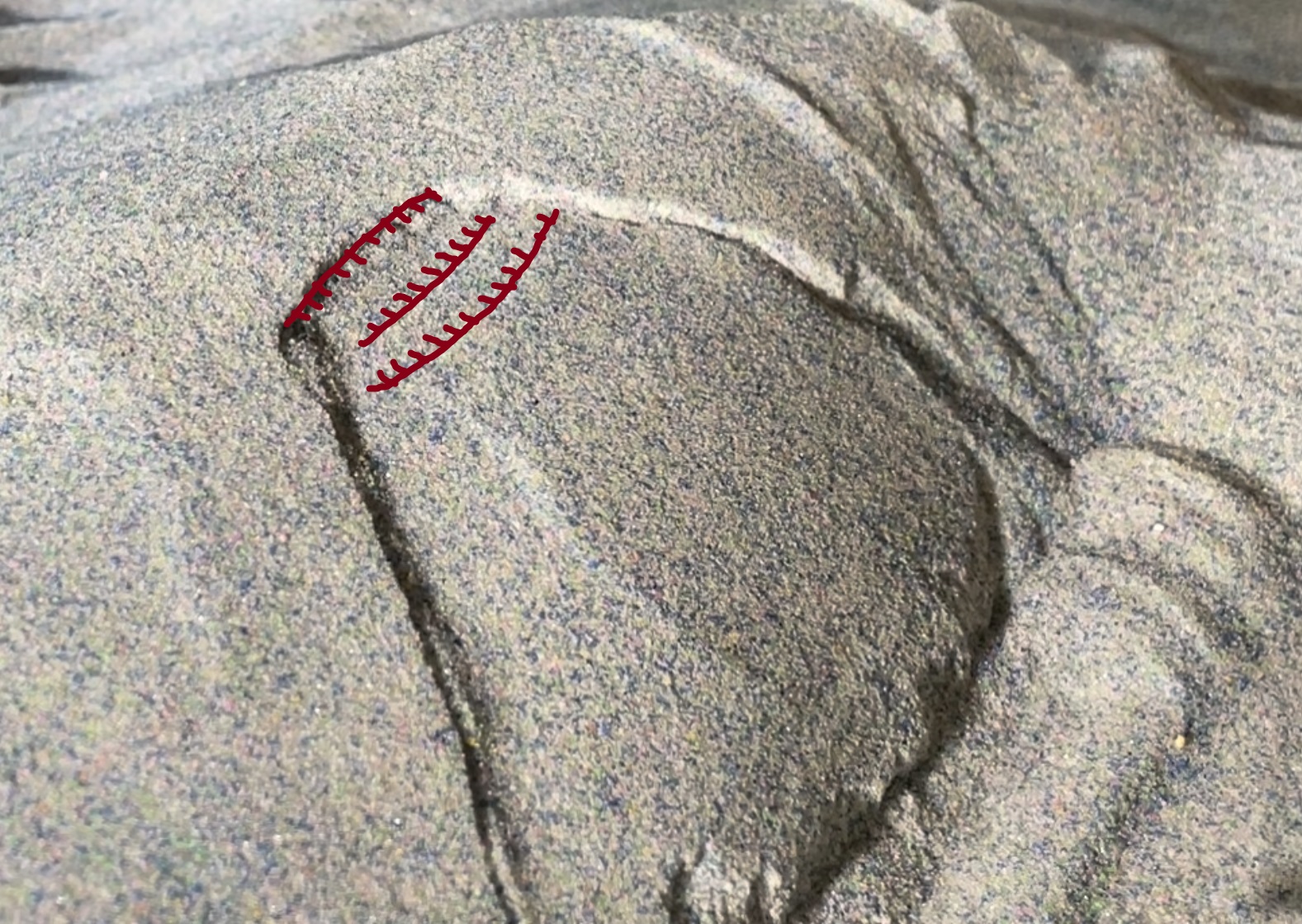
I think the most interesting aspect of this human-induced topographic “adjustment” is how a very modest excavation produced an equally modest slope movement, at least in terms of overall displacement of the moving mass of hillslope. None of the mining-related slope movements in the area appear to have produced rapid, long-runout slides or flows; all resulted in slight shifts that are really only discernible with lidar-derived imagery. All are reforested, and lidar imagery does not suggest any are subject to imminent significant movement. I tried to set up a simple physical model to capture this behavior. Two trials are shown below. The model hillslope is constructed of a cohesive sand-and-flour “shell” over a weak glass microbead core. With disturbance of the toe of the slope, a small, lurching failure occurs, reestablishing equilibrium and stability with a tiny but obvious movement.

Setting these models up to produce this style of failure was a worthy challenge. Their behavior is definitely material-specific; cohesive or loose sand alone (or microbeads) won’t do it. The slope has to be just unstable enough–and mechanically appropriate–to settle slightly with minor disturbance to the toe of the slope. The failures are not as deep-seated with respect to the slope as the real graben scenario, but they are deep enough to produce back rotation of the head of the slide with very little displacement, as shown below. Scarps and counterscarps are marked with hachured lines.
While these models experience rapid, one-time movement, the amount of movement necessary to reestablish stability is very small. This was the goal of the models, specifically as a way of connecting the slope’s mechanical architecture to failure behavior. A very brief YouTube video linked below shows the actual failures at full speed. It seems ridiculous to go to great lengths for such tiny movement, but it was much more challenging than producing a high-runout model, for sure.
While the summit graben feature is an extreme example, mine-related failures abound in this area. The image below shows other failures just up the valley from the graben feature. Again, cuts on contour appear to be the issue, but slopes responded with modest movement. In the image below, a large area of slight displacement is clearly visible above a highwall cut. The hill with the graben is just outside the field of view to the right. More examples exist just southwest of this one.

The location of these slope has largely spared them from modern-day engineering, but it is interesting to consider how they might respond to more carefully planned modification! It also invites comparison to the well-documented Rattlesnake Ridge landslide in Washington.
